ArcGIS Collection for Architecture, Engineering and Construction
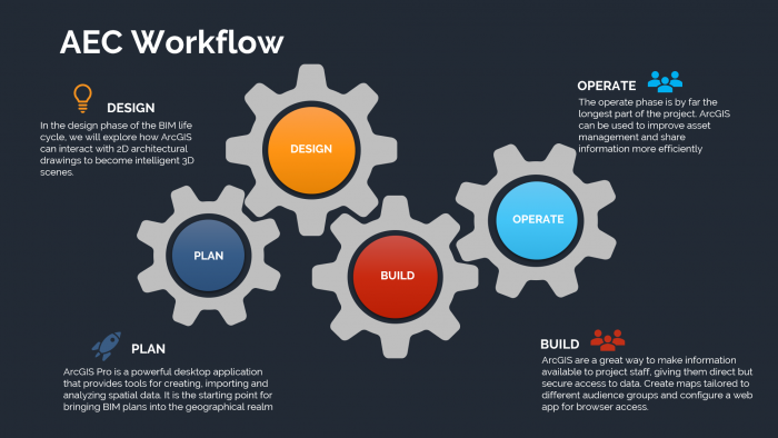
The solution draws the advantage of spatial analyses and applies them to architectural, engineering and construction work. It simplifies complex processes and facilitates the entire workflow from design to construction.

Architecture
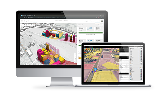
The software has Apps and tools that enable the drafting of a building’s plan and 3D simulation based on the height restriction, floor area ratio (FAR), open space ratio (OSR) and compulsory empty space according to the city planning and building control laws. It can also predict population growth in the area and calculate living space according to the Building Control Act under different scenarios for an environmental impact assessment.

The software is equipped with functions for designers well-versed with the Autodesk App. The features take advantage of GIS location data and other layers to provide an in-depth representation complete with surrounding roads, infrastructure, the environment and landscape. The functions make it possible to design a building that corresponds to the environment as much as possible while minimizing impacts on the environment.

Engineering
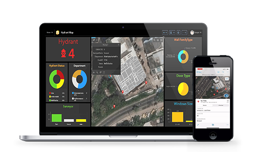
The platform has a ready-to-use App that can simplify complex processes and steps in updating the work progress onsite. Engineers can check a device’s functionality, parts installation and working hours of employees via the App on mobile devices. The information is updated and presented as an interactive, real-time dashboard which can also be turned into document-style reports immediately.
Construction
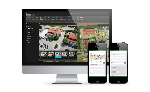
The App provides an overview of the construction project and summarizes its progress. It can present 3D results. The App can store data and present them daily which allow users to monitor each step of a project’s progress conveniently and quickly. The feature allows engineers or clients to check on the project’s status without having to travel to the construction site.

ArcGIS Collection for Architecture, Engineering and Construction
The solution draws the advantage of spatial analyses and applies them to architectural, engineering and construction work. It simplifies complex processes and facilitates the entire workflow from design to construction.


Architecture
The software has Apps and tools that enable the drafting of a building’s plan and 3D simulation based on the height restriction, floor area ratio (FAR), open space ratio (OSR) and compulsory empty space according to the city planning and building control laws. It can also predict population growth in the area and calculate living space according to the Building Control Act under different scenarios for an environmental impact assessment.
The software is equipped with functions for designers well-versed with the Autodesk App. The features take advantage of GIS location data and other layers to provide an in-depth representation complete with surrounding roads, infrastructure, the environment and landscape. The functions make it possible to design a building that corresponds to the environment as much as possible while minimizing impacts on the environment.

Engineering
The platform has a ready-to-use App that can simplify complex processes and steps in updating the work progress onsite. Engineers can check a device’s functionality, parts installation and working hours of employees via the App on mobile devices. The information is updated and presented as an interactive, real-time dashboard which can also be turned into document-style reports immediately.

Construction
The App provides an overview of the construction project and summarizes its progress. It can present 3D results. The App can store data and present them daily which allow users to monitor each step of a project’s progress conveniently and quickly. The feature allows engineers or clients to check on the project’s status without having to travel to the construction site.
